
Map of Germany

Choosing the Best Navigation Apps for Germany
Selecting the optimal navigation app is crucial for a seamless journey across Germany, whether you are driving, walking, or utilizing public transport. Google Maps remains a widely used and highly versatile option, offering comprehensive routing for various modes of travel, while Apple Maps provides a strong alternative, particularly for iOS users seeking integrated experiences. For those prioritizing robust offline capabilities, HERE WeGo, formerly Nokia Maps, stands out as an excellent choice, ensuring reliable navigation even without an internet connection. Enthusiasts of cycling and hiking will find Komoot invaluable, as it specializes in detailed outdoor routes often supplemented with topographic maps, making it an essential tool for exploring Germany’s scenic landscapes.
Beyond these popular choices, the German Automobile Club (ADAC) offers its own comprehensive road maps and navigation services via adac.de, providing trusted information for drivers. Many navigation platforms, including some of the aforementioned, leverage community-driven data from OpenStreetMap, ensuring up-to-date and detailed Germany travel maps. When planning your routes, consider the specific needs of your trip to determine which app will best serve your navigational requirements across the diverse German terrain.
Offline Maps & Saving Mobile Data
To effectively manage mobile data costs and ensure uninterrupted navigation, downloading offline maps for your planned regions in Germany is an essential insider tip, especially when venturing into rural areas where connectivity might be sporadic. Providers like Telekom, Vodafone, and O2 offer prepaid SIM card packages where the average mobile data cost for 1GB typically ranges from EUR 5-10, making data conservation a smart strategy. Offline map downloads for Germany via Google Maps or HERE WeGo usually range from 500MB to 1.5GB, depending on the level of detail and the specific regions selected, so plan your downloads accordingly.
Leveraging free public Wi-Fi, which is widely available in German city centers, train stations (Deutsche Bahn), and numerous cafes and restaurants, facilitates these larger offline map downloads without incurring data charges. Always ensure your Germany travel maps are pre-downloaded before you depart, as this proactive step guarantees access to critical navigation information regardless of your network signal, significantly enhancing your travel experience and preventing unexpected data overages.
Navigating German Public Transport
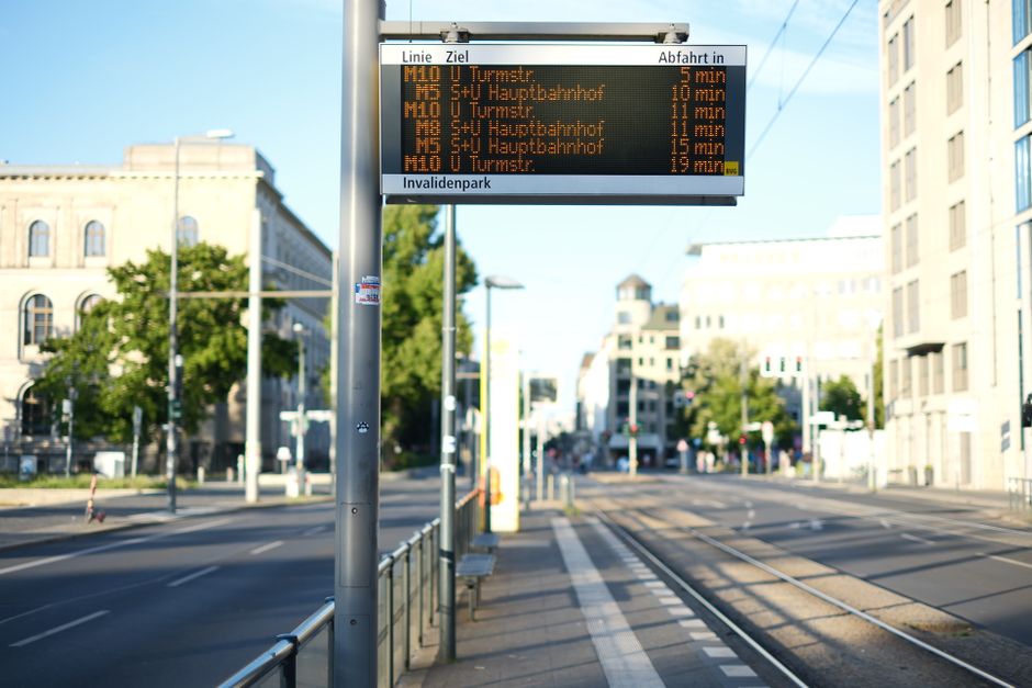
Germany’s public transport system is renowned for its efficiency and punctuality, and navigating it is made significantly easier with the right digital tools. Public transport routing in major German cities is exceptionally accurate on both Google Maps and Apple Maps, often integrating real-time data for buses, trams, and trains, which provides up-to-the-minute information on arrivals and departures. However, for nationwide train travel and more granular local data, supplementing these generic map apps with the official ‘DB Navigator’ app from Deutsche Bahn is highly recommended; it offers detailed train and bus routes, station maps, and even allows for ticket purchases directly within the application.
For specific urban areas, local transport apps provide even more precise real-time updates and ticketing options; examples include ‘BVG Fahrinfo’ for Berlin and the ‘MVV-App’ for Munich. These specialized applications offer a deeper level of local insight, ensuring you have the most current information for seamless travel within Germany’s bustling cities. Utilizing these dedicated apps alongside your general Germany travel maps will optimize your public transport experience.

Driving in Germany: Understanding Environmental Zones
When driving in Germany, it is imperative to understand the concept of ‘Umweltzonen’ (environmental zones), which are designated areas in over 50 German cities, including major hubs like Berlin, Munich, and Cologne, designed to reduce air pollution. Entry into these zones requires a ‘Feinstaubplakette’ (emission sticker) affixed to your vehicle, indicating its emission class. A critical insider tip for drivers is to be vigilant for ‘Umweltzonen’ signs, as standard navigation apps may not always provide explicit warnings or sufficient detail about these zones, potentially leading to unexpected fines.
If your rental car lacks the necessary ‘Feinstaubplakette’, it is crucial to plan your routes to bypass these environmental zones entirely to avoid penalties, which can be substantial. While your Germany travel maps will guide you on the most efficient routes, always cross-reference with local signage and be aware of these specific regulations. Consulting resources from the ADAC (German Automobile Club) can also provide up-to-date information on environmental zone requirements and help ensure a compliant and stress-free driving experience.